Restren:CornwallKernowMappa.png
Myns an ragwel ma: 800 × 587 piksel. Klerderyow erel: 320 × 235 piksel | 640 × 469 piksel | 952 × 698 piksel.
Restren wreydhek (952 × 698 piksel, myns an restren: 167 KB, eghen MIME: image/png)
| Restren dhyworth Wikimedia Commons yw hebma. Yma diskwedhys a-woles derivadow dhyworth y folen deskrifans ena. | Mos dhe folen an restren war Wikimedia Commons |
Berrskrif
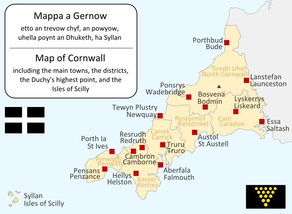
I made this map myself in September 2004. It is bilingual in Cornish and English, and shows the modern-day administrative boundaries of Cornwall and the larger towns. QuartierLatin1968 17:36, 14 Apr 2005 (UTC)

|
Permission is granted to copy, distribute and/or modify this document under the terms of the GNU Free Documentation License, Version 1.2 or any later version published by the Free Software Foundation; with no Invariant Sections, no Front-Cover Texts, and no Back-Cover Texts. A copy of the license is included in the section entitled GNU Free Documentation License. |
| Yma an restren ma yn-dann an leshyans Creative Commons Attribution-Share Alike 3.0 Unported. | ||
| ||
| This licensing tag was added to this file as part of the GFDL licensing update. |
| Annotations | This image is annotated: View the annotations at Commons |
Istori an restren
Klyckyewgh war dhedhyans/eur rag gweles an folen dell o an termyn na.
| Dedhyans/Eur | Skeusennik | Mynsow | Devnydhyer | Kampol | |
|---|---|---|---|---|---|
| a-lemmyn | 19:09, 23 Metheven 2011 | | 952 × 698 (167 KB) | Lader Gwiader | improve, SWF, place names from "A Concise Dictionary of Cornish Place Names" |
| 04:38, 21 Est 2005 |  | 643 × 469 (30 KB) | QuartierLatin1968 | one or two grammatical fixes, less jarring colours | |
| 17:33, 14 Ebrel 2005 |  | 644 × 474 (21 KB) | QuartierLatin1968 | I made this map myself in September 2004. It is bilingual in Cornish and English, and shows the modern-day administrative boundaries of Cornwall and the larger towns. {{GFDL}} |
Devnydh an restren
Yma an 3 folen a syw owth usya an restren ma:
Devnydh ollvysel an restren
Yma an wikis erel a syw ow tevnydhya an restren ma:
- Devnydh war af.wikipedia.org
- Devnydh war an.wikipedia.org
- Devnydh war ast.wikipedia.org
- Devnydh war br.wikipedia.org
- Devnydh war ca.wikipedia.org
- Devnydh war cs.wikipedia.org
- Devnydh war cy.wikipedia.org
- Devnydh war el.wiktionary.org
- Devnydh war en.wikipedia.org
- Devnydh war eo.wikipedia.org
- Devnydh war es.wikipedia.org
- Devnydh war frr.wikipedia.org
- Devnydh war fr.wikipedia.org
- Devnydh war fy.wikipedia.org
- Devnydh war gd.wikipedia.org
- Devnydh war he.wikipedia.org
- קורנית (שפה)
- תבנית:הידעת? 10 ביולי - סדרה 2
- פורטל:הממלכה המאוחדת/הידעת?/קטעי הידעת?
- פורטל:בלשנות/הידעת?/קטעי הידעת
- פורטל:בלשנות/הידעת?/10
- פורטל:הממלכה המאוחדת/הידעת?/17
- תבנית:הידעת? 10 ביולי 2013
- ויקיפדיה:הידעת?/2013/יולי
- ויקיפדיה:הידעת?/2016/יולי
- תבנית:הידעת? 12 ביולי 2016
- ויקיפדיה:הידעת?/2018/יולי
- תבנית:הידעת? 19 ביולי 2018
- ויקיפדיה:הידעת?/2019/יולי
- תבנית:הידעת? 10 ביולי 2019
Gweles devnydh ollvysel moy a'n restren ma.