Restren:Crackington Haven.jpg
Nyns eus klerder ughella kavadow.
Crackington_Haven.jpg (640 × 480 piksel, myns an restren: 47 KB, eghen MIME: image/jpeg)
| Restren dhyworth Wikimedia Commons yw hebma. Yma diskwedhys a-woles derivadow dhyworth y folen deskrifans ena. | Mos dhe folen an restren war Wikimedia Commons |
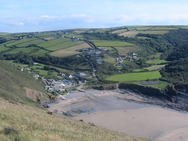
| Deskrifans |
English: Crackington Haven, Cornwall. Taken from the cliff around SX140972, but covering a good proportion of the SX1496 grid square with Crackington Haven nestling at the bottom of the valley. This was taken in 2003, before the 2004 floods which washed away the car park and footbridge. |
| Dedhyans | |
| Pennfenten | From geograph.org.uk |
| Awtour | Paul Dixon |
| Kummyas (Dastevnydhya an restren ma) |
Creative Commons Attribution Share-alike license 2.0 |
| Camera location | | View this and other nearby images on: OpenStreetMap |
|---|

|
This image was taken from the Geograph project collection. See this photograph's page on the Geograph website for the photographer's contact details. The copyright on this image is owned by Paul Dixon and is licensed for reuse under the Creative Commons Attribution-ShareAlike 2.0 license.
|
This file is licensed under the Creative Commons Attribution-Share Alike 2.0 Generic license.
Askrifans: Paul Dixon
- Yma'n gwir dhywgh:
- a ranna – a dhasskrifa, lesranna ha treuskorra an ober
- a gemyska – a aswiwa an ober
- Yn-dann an ragselyow a syw:
- askrifans – Res yw dhywgh ri askrifans gwiw, provia kevren dhe'n lecyans, ha meneges mar peu chanjyow gwrys. Hwi a yll gul hemma yn fordh resonus a vynnowgh, mes ny yllir y wul yn fordh a broffo synser an lecyans dh'agas skoodhya po agas devnydh.
- ranna kehaval – Mar kwrewgh hwi chanjya, treusfurvya po drehevel war an ober ma, res yw dhywgh lesranna agas kevrohow yn-dann an keth lecyans hag an derowel, po lecyans kesplegadow.
Original upload log
The original description page was here. All following user names refer to en.wikipedia.
- 2007-12-05 11:11 Rodw 640×480×8 (48514 bytes) Crackington Haven Taken from the cliff around SX140972, but covering a good proportion of the SX1496 grid square with Crackington Haven nestling at the bottom of the valley. This was taken in 2003, before the 2004 floods which washed away the car park and
Istori an restren
Klyckyewgh war dhedhyans/eur rag gweles an folen dell o an termyn na.
| Dedhyans/Eur | Skeusennik | Mynsow | Devnydhyer | Kampol | |
|---|---|---|---|---|---|
| a-lemmyn | 22:23, 14 Gortheren 2008 | | 640 × 480 (47 KB) | Angusmclellan | {{Information |Description={{en|Crackington Haven, Cornwall. Taken from the cliff around SX140972, but covering a good proportion of the SX1496 grid square with Crackington Haven nestling at the bottom of the valley. This was taken in 2003, before the 200 |
Devnydh an restren
Yma an folen a syw owth usya an restren ma:
Devnydh ollvysel an restren
Yma an wikis erel a syw ow tevnydhya an restren ma:
- Devnydh war en.wikipedia.org
- Devnydh war eu.wikipedia.org
- Devnydh war hu.wikipedia.org