Restren:Global Vegetation map - GPN-2003-00029.jpg
Myns an ragwel ma: 750 × 600 piksel. Klerderyow erel: 300 × 240 piksel | 600 × 480 piksel | 960 × 768 piksel | 1,280 × 1,024 piksel | 2,560 × 2,048 piksel | 3,000 × 2,400 piksel.
Restren wreydhek (3,000 × 2,400 piksel, myns an restren: 6.92 MB, eghen MIME: image/jpeg)
| Restren dhyworth Wikimedia Commons yw hebma. Yma diskwedhys a-woles derivadow dhyworth y folen deskrifans ena. | Mos dhe folen an restren war Wikimedia Commons |
| Deskrifans |
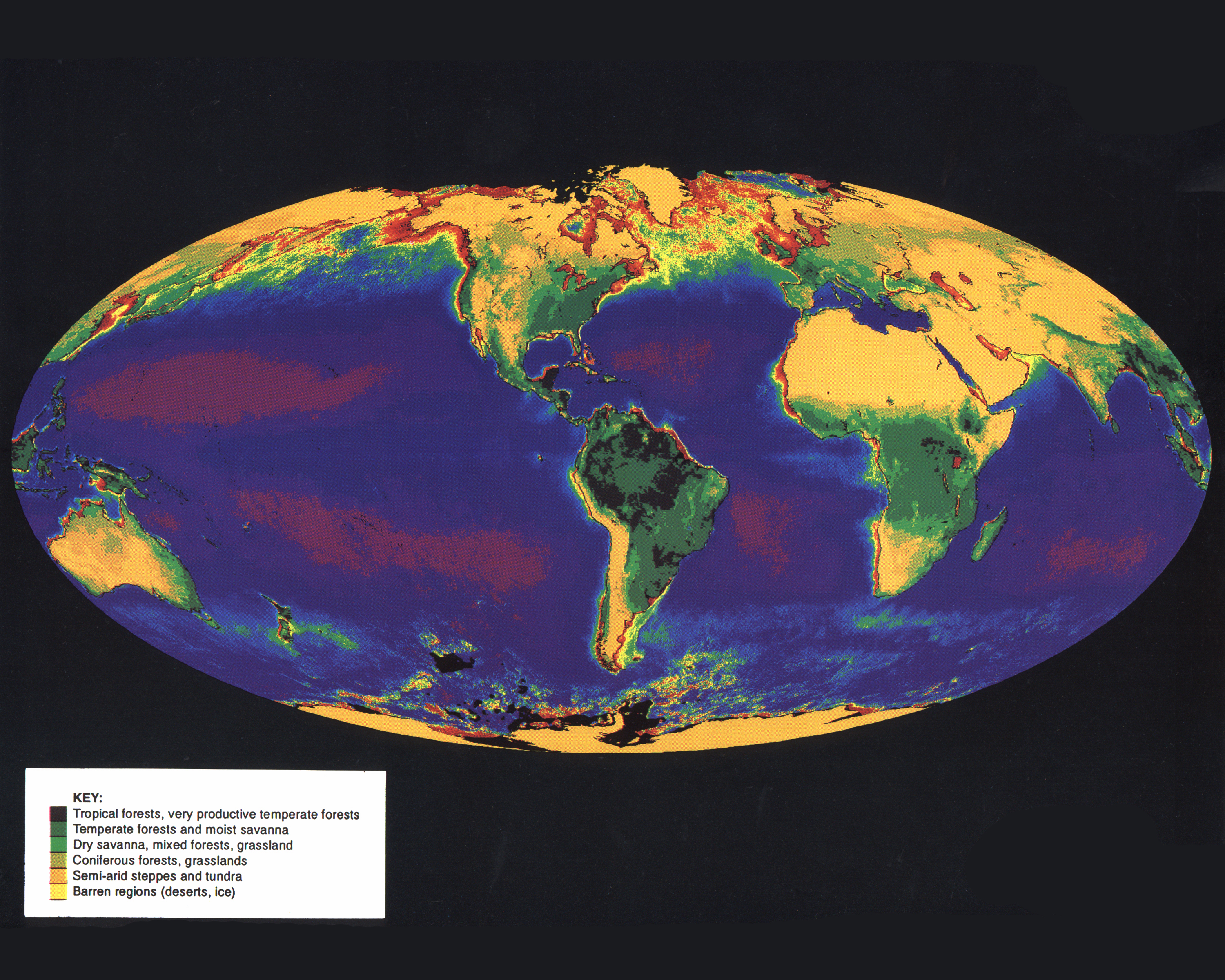
English: This image is comprised of data from the Advanced Very High Resolution Radiometer (AVHRR) aboard the National Oceanic and Atmospheric Administration's (NOAA) Polar Orbiting Environmental Satellite (POES) series to map global vegetation cover. The vegetation covering the continents was recorded by the AVHRR aboard NOAA-7, NOAA-8, and NOAA-11. Dense vegetation is represented by shades of purple and green; sparse vegetation by shades of brown. The vegetation "index," an indicator of vegetation cover, is calculated by comparing reflected infrared light to reflected visible light for a specific area of land. NOAA's two operational polar orbiting satellites scan the entire earth once every six hours from altitudes of about 850km (529 miles). The data collected by the AVHRR sensor are held in the archives of the United States Geological Survey's EROS Data Center. The objective of the AVHRR instrument was to provide radiance data for investigation of clouds, land-water boundaries, snow and ice extent, ice or snow melt inception, day and night cloud distribution, temperatures of radiating surfaces, and sea surface temperature. |
|||||
| Dedhyans | ||||||
| Pennfenten | Great Images in NASA Description | |||||
| Awtour | NASA | |||||
| Kummyas (Dastevnydhya an restren ma) |
|

This image or video was catalogued by NASA Headquarters of the United States National Aeronautics and Space Administration (NASA) under Photo ID: GPN-2003-00029 and Alternate ID: Global-Biosphere. This tag does not indicate the copyright status of the attached work. A normal copyright tag is still required. See Commons:Licensing. Other languages:
|
Istori an restren
Klyckyewgh war dhedhyans/eur rag gweles an folen dell o an termyn na.
| Dedhyans/Eur | Skeusennik | Mynsow | Devnydhyer | Kampol | |
|---|---|---|---|---|---|
| a-lemmyn | 00:16, 10 Ebrel 2009 | | 3,000 × 2,400 (6.92 MB) | BotMultichillT | {{Information |Description={{en|1=This image is comprised of data from the Advanced Very High Resolution Radiometer (AVHRR) aboard the National Oceanic and Atmospheric Administration's (NOAA) Polar Orbiting Environmental Satellite (POES) series to map glo |
Devnydh an restren
Yma an folen a syw owth usya an restren ma:
Devnydh ollvysel an restren
Yma an wikis erel a syw ow tevnydhya an restren ma:
- Devnydh war de.wikipedia.org
- Devnydh war simple.wikipedia.org