Restren:HeadwatersGanges1.jpg
Myns an ragwel ma: 487 × 600 piksel. Klerderyow erel: 195 × 240 piksel | 390 × 480 piksel | 623 × 768 piksel | 831 × 1,024 piksel | 2,000 × 2,464 piksel.
Restren wreydhek (2,000 × 2,464 piksel, myns an restren: 339 KB, eghen MIME: image/jpeg)
| Restren dhyworth Wikimedia Commons yw hebma. Yma diskwedhys a-woles derivadow dhyworth y folen deskrifans ena. | Mos dhe folen an restren war Wikimedia Commons |
| Deskrifans |
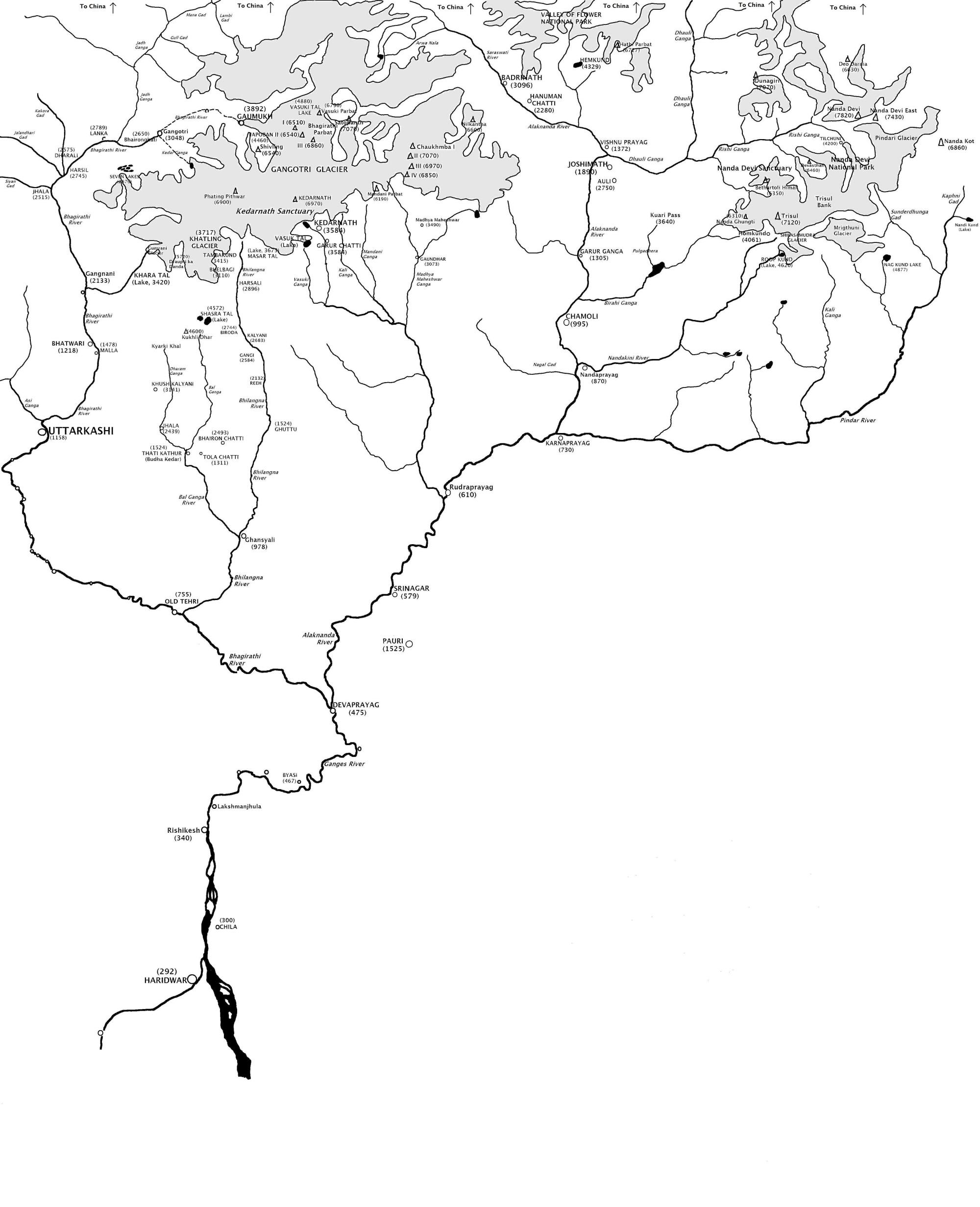
English: Map showing the Himalayan headwaters of the Ganges river of the Indian subcontinent. The map is based on the map in . That map in turn is based on the map of the region produced by the Surveyor General of India. |
| Dedhyans | |
| Pennfenten | Ober honan (Original text: I created this work entirely by myself.) |
| Awtour | Fowler&fowler«Talk» |
| Other versions |

Leshyans
[[:w:en:{{{1}}}|{{{1}}}]]
Fowler&fowler at Sowsnek Wikipedya, the copyright holder of this work, hereby publishes it under the following licenses:
Yma an restren ma yn-dann an leshyans Creative Commons Attribution-Share Alike 3.0 Unported.
Askrifans: Fowler&fowler at Sowsnek Wikipedya
- Yma'n gwir dhywgh:
- a ranna – a dhasskrifa, lesranna ha treuskorra an ober
- a gemyska – a aswiwa an ober
- Yn-dann an ragselyow a syw:
- askrifans – Res yw dhywgh ri askrifans gwiw, provia kevren dhe'n lecyans, ha meneges mar peu chanjyow gwrys. Hwi a yll gul hemma yn fordh resonus a vynnowgh, mes ny yllir y wul yn fordh a broffo synser an lecyans dh'agas skoodhya po agas devnydh.
- ranna kehaval – Mar kwrewgh hwi chanjya, treusfurvya po drehevel war an ober ma, res yw dhywgh lesranna agas kevrohow yn-dann an keth lecyans hag an derowel, po lecyans kesplegadow.

|
Permission is granted to copy, distribute and/or modify this document under the terms of the GNU Free Documentation License, Version 1.2 or any later version published by the Free Software Foundation; with no Invariant Sections, no Front-Cover Texts, and no Back-Cover Texts. A copy of the license is included in the section entitled GNU Free Documentation License. |
You may select the license of your choice.
Original upload log
The original description page was here. All following user names refer to en.wikipedia.
- 2009-04-10 21:36 Fowler&fowler 2000×2464× (346958 bytes) {{Information |Description = Map showing the [[Himalayas|Himalayan]] headwaters of the [[Ganges river]] of the [[Indian subcontinent]]. The map is based on the map in {{Harvard reference|editor-last=Agarwala|editor-first=A. P.|title=Uttarakhand Encyc
Istori an restren
Klyckyewgh war dhedhyans/eur rag gweles an folen dell o an termyn na.
| Dedhyans/Eur | Skeusennik | Mynsow | Devnydhyer | Kampol | |
|---|---|---|---|---|---|
| a-lemmyn | 17:55, 22 Metheven 2009 | | 2,000 × 2,464 (339 KB) | Lohen11 | {{Information |Description={{en|Map showing the Himalayan headwaters of the en:Ganges river of the en:Indian subcontinent. The map is based on the map in . That map in turn is based on the map of the region produced by the |
Devnydh an restren
Yma an folen a syw owth usya an restren ma:
Devnydh ollvysel an restren
Yma an wikis erel a syw ow tevnydhya an restren ma:
- Devnydh war as.wikipedia.org
- Devnydh war azb.wikipedia.org
- Devnydh war ba.wikipedia.org
- Devnydh war bh.wikipedia.org
- Devnydh war bn.wikipedia.org
- Devnydh war bo.wikipedia.org
- Devnydh war ca.wikipedia.org
- Devnydh war cv.wikipedia.org
- Devnydh war el.wikipedia.org
- Devnydh war en.wikipedia.org
- Devnydh war es.wikipedia.org
- Devnydh war fa.wikipedia.org
- Devnydh war fr.wikipedia.org
- Devnydh war gu.wikipedia.org
- Devnydh war hi.wikipedia.org
- Devnydh war ilo.wikipedia.org
- Devnydh war ja.wikipedia.org
- Devnydh war kbd.wikipedia.org
- Devnydh war kn.wikipedia.org
- Devnydh war ku.wikipedia.org
- Devnydh war mai.wikipedia.org
- Devnydh war pt.wikipedia.org
- Devnydh war ro.wikipedia.org
- Devnydh war ru.wikipedia.org
- Devnydh war sat.wikipedia.org
- Devnydh war simple.wikipedia.org
- Devnydh war szy.wikipedia.org
- Devnydh war ta.wikipedia.org
- Devnydh war tcy.wikipedia.org
- Devnydh war te.wikipedia.org
- Devnydh war uk.wikipedia.org
Gweles devnydh ollvysel moy a'n restren ma.