Restren:Mid-ocean ridge topography.gif
Nyns eus klerder ughella kavadow.
Mid-ocean_ridge_topography.gif (240 × 180 piksel, myns an restren: 1.06 MB, eghen MIME: image/gif, looped, 70 frames, 14 s)
| Restren dhyworth Wikimedia Commons yw hebma. Yma diskwedhys a-woles derivadow dhyworth y folen deskrifans ena. | Mos dhe folen an restren war Wikimedia Commons |
Berrskrif
| Deskrifans |
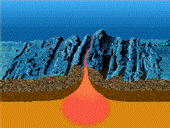
English: A close-up showing mid-ocean ridge topography with magma chamber below, which rises and new ocean plates spreads away from ridge. |
| Dedhyans | |
| Pennfenten | http://geomaps.wr.usgs.gov/parks/animate/index.html |
| Awtour | USGS |
Leshyans
This image is in the public domain in the United States because it only contains materials that originally came from the United States Geological Survey, an agency of the United States Department of the Interior. For more information, see the official USGS copyright policy.
|
Istori an restren
Klyckyewgh war dhedhyans/eur rag gweles an folen dell o an termyn na.
| Dedhyans/Eur | Skeusennik | Mynsow | Devnydhyer | Kampol | |
|---|---|---|---|---|---|
| a-lemmyn | 15:04, 19 Hwevrer 2011 | | 240 × 180 (1.06 MB) | דקי | {{Information |Description ={{en|1=A close-up showing mid-ocean ridge topography with magma chamber below, which rises and new ocean plates spreads away from ridge.}} |Source =http://geomaps.wr.usgs.gov/parks/animate/index.html |Author |
Devnydh an restren
Yma an 2 folen a syw owth usya an restren ma:
Devnydh ollvysel an restren
Yma an wikis erel a syw ow tevnydhya an restren ma:
- Devnydh war an.wikipedia.org
- Devnydh war ar.wikipedia.org
- Devnydh war ast.wikipedia.org
- Devnydh war az.wikipedia.org
- Devnydh war bg.wikipedia.org
- Devnydh war ca.wikipedia.org
- Devnydh war de.wikipedia.org
- Devnydh war de.wiktionary.org
- Devnydh war en.wikipedia.org
- Devnydh war en.wikiquote.org
- Devnydh war es.wikipedia.org
- Devnydh war eu.wikipedia.org
- Devnydh war fi.wikipedia.org
- Devnydh war fr.wikipedia.org
- Devnydh war gl.wikipedia.org
- Devnydh war he.wikipedia.org
- Devnydh war hi.wikipedia.org
- Devnydh war hu.wikipedia.org
- Devnydh war it.wikipedia.org
- Devnydh war it.wikibooks.org
- Devnydh war it.wikiversity.org
- Devnydh war ja.wikipedia.org
- Devnydh war ja.wikibooks.org
- Devnydh war ko.wikipedia.org
- Devnydh war lv.wikipedia.org
- Devnydh war mk.wikipedia.org
- Devnydh war ml.wikipedia.org
- Devnydh war nds.wikipedia.org
Gweles devnydh ollvysel moy a'n restren ma.