Restren:Modelare 3D pentru Bazinul Hidrografic al Paraului Latorita.gif
Nyns eus klerder ughella kavadow.
Modelare_3D_pentru_Bazinul_Hidrografic_al_Paraului_Latorita.gif (300 × 214 piksel, myns an restren: 7.21 MB, eghen MIME: image/gif, looped, 180 frames, 11 s)
| Restren dhyworth Wikimedia Commons yw hebma. Yma diskwedhys a-woles derivadow dhyworth y folen deskrifans ena. | Mos dhe folen an restren war Wikimedia Commons |
Berrskrif
| Deskrifans |
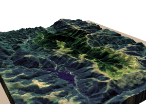
Română: Modelare 3D pentru Bazinul Hidrografic al Râului Latorița. Elevație 130%. Magyar: a Latorca folyó vízgyűjtő területének 3D ábrázolása |
| Dedhyans | |
| Pennfenten | Topographic data SRTM from NASA and World Imagery - NASA World Wind & 3Dem & Inkscape |
| Awtour | Asybaris01 |
| Other versions |
 |
Clickable map of the (ro:Defileul Oltului)/(en:Defile Olt) drainage basin

Leshyans
| This image is in the public domain because it is a screenshot from NASA’s globe software World Wind using a public domain layer, such as Blue Marble, MODIS, Landsat, SRTM, USGS or GLOBE.
|
 |
Istori an restren
Klyckyewgh war dhedhyans/eur rag gweles an folen dell o an termyn na.
| Dedhyans/Eur | Skeusennik | Mynsow | Devnydhyer | Kampol | |
|---|---|---|---|---|---|
| a-lemmyn | 07:35, 21 Hedra 2011 | | 300 × 214 (7.21 MB) | Asybaris01 | {{Information |Description ={{ro|1=Modelare 3D pentru Bazinul Hidrografic al Paraului Latorita.gif}} |Source =Topographic data SRTM from NASA and World Imagery - NASA World Wind & 3Dem & Inkscape |Author =Asybaris01 |
Devnydh an restren
Yma an folen a syw owth usya an restren ma:
Devnydh ollvysel an restren
Yma an wikis erel a syw ow tevnydhya an restren ma:
- Devnydh war af.wikipedia.org
- Devnydh war ar.wikipedia.org
- Devnydh war el.wikipedia.org
- Devnydh war fa.wikipedia.org
- Devnydh war ga.wikipedia.org
- Devnydh war hu.wikipedia.org
- Devnydh war it.wikipedia.org
- Devnydh war it.wikibooks.org
- Devnydh war ka.wikipedia.org
- Devnydh war ka.wiktionary.org
- Devnydh war lld.wikipedia.org
- Devnydh war ms.wikipedia.org
- Devnydh war my.wikipedia.org
- Devnydh war ro.wikipedia.org
- Devnydh war th.wikipedia.org
- Devnydh war tr.wikipedia.org
- Devnydh war vi.wikipedia.org
- Devnydh war www.wikidata.org