Restren:Wavecut platform southerndown pano.jpg
Myns an ragwel ma: 800 × 401 piksel. Klerderyow erel: 320 × 160 piksel | 640 × 321 piksel | 1,024 × 513 piksel | 1,280 × 642 piksel | 2,393 × 1,200 piksel.
Restren wreydhek (2,393 × 1,200 piksel, myns an restren: 1.7 MB, eghen MIME: image/jpeg)
| Restren dhyworth Wikimedia Commons yw hebma. Yma diskwedhys a-woles derivadow dhyworth y folen deskrifans ena. | Mos dhe folen an restren war Wikimedia Commons |
Berrskrif
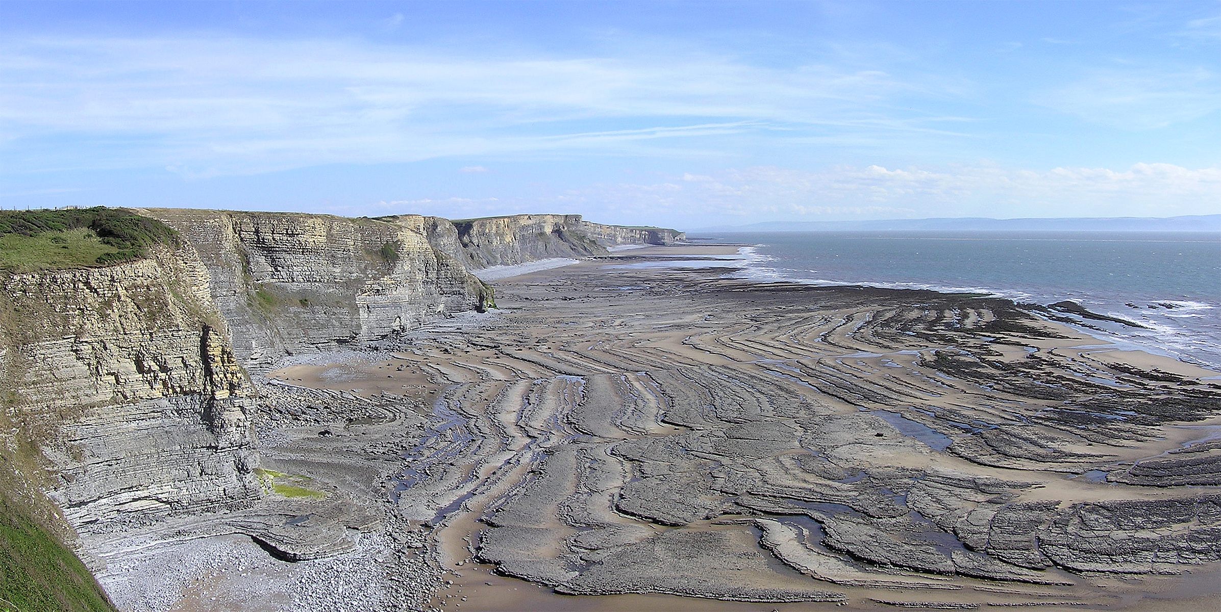
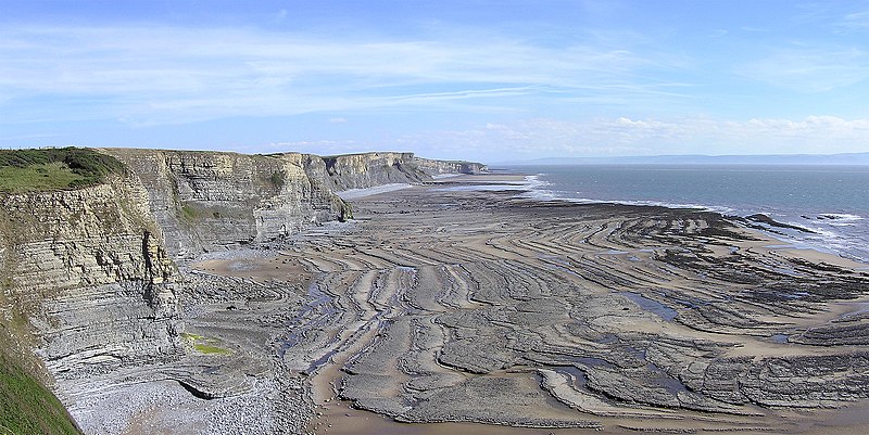
Wavecut platform, a geological feature caused by the sea's erosion of cliffs, seen at Southerndown near Bridgend, South Wales.
Image by Yummifruitbat using an Olympus C-750UZ.
| Camera location | | View this and other nearby images on: OpenStreetMap |
|---|
Leshyans
This file is licensed under the Creative Commons Attribution-Share Alike 2.5 Generic license.
- Yma'n gwir dhywgh:
- a ranna – a dhasskrifa, lesranna ha treuskorra an ober
- a gemyska – a aswiwa an ober
- Yn-dann an ragselyow a syw:
- askrifans – Res yw dhywgh ri askrifans gwiw, provia kevren dhe'n lecyans, ha meneges mar peu chanjyow gwrys. Hwi a yll gul hemma yn fordh resonus a vynnowgh, mes ny yllir y wul yn fordh a broffo synser an lecyans dh'agas skoodhya po agas devnydh.
- ranna kehaval – Mar kwrewgh hwi chanjya, treusfurvya po drehevel war an ober ma, res yw dhywgh lesranna agas kevrohow yn-dann an keth lecyans hag an derowel, po lecyans kesplegadow.
Istori an restren
Klyckyewgh war dhedhyans/eur rag gweles an folen dell o an termyn na.
| Dedhyans/Eur | Skeusennik | Mynsow | Devnydhyer | Kampol | |
|---|---|---|---|---|---|
| a-lemmyn | 01:19, 9 Me 2006 | | 2,393 × 1,200 (1.7 MB) | Yummifruitbat | Wavecut platform, a geological feature caused by the sea's erosion of cliffs, seen at Southerndown near Bridgend, South Wales. <br>Image by Yummifruitbat using an Olympus C-750UZ. |
Devnydh an restren
Yma an folen a syw owth usya an restren ma:
Devnydh ollvysel an restren
Yma an wikis erel a syw ow tevnydhya an restren ma:
- Devnydh war af.wikipedia.org
- Devnydh war ar.wikipedia.org
- Devnydh war ast.wikipedia.org
- Devnydh war bg.wikipedia.org
- Devnydh war ckb.wikipedia.org
- Devnydh war de.wikipedia.org
- Devnydh war en.wikipedia.org
- Devnydh war en.wikibooks.org
- Devnydh war es.wikipedia.org
- Devnydh war eu.wikipedia.org
- Devnydh war fa.wikipedia.org
- Devnydh war gl.wikipedia.org
- Devnydh war ha.wikipedia.org
- Devnydh war hu.wikipedia.org
- Devnydh war it.wikibooks.org
- Devnydh war it.wikiversity.org
- Devnydh war kn.wikipedia.org
- Devnydh war pa.wikipedia.org
- Devnydh war pl.wikipedia.org
- Devnydh war pl.wiktionary.org
- Devnydh war pt.wikipedia.org
- Devnydh war ro.wikipedia.org
- Devnydh war sl.wikipedia.org
- Devnydh war tr.wikipedia.org
- Devnydh war uk.wikipedia.org
- Devnydh war vi.wikipedia.org
- Devnydh war www.wikidata.org
- Devnydh war zh.wikipedia.org