Restren:Dromaius novaehollandiae map distribution 2.svg

Size of this PNG preview of this SVG file: 736 × 600 piksel. Klerderyow erel: 295 × 240 piksel | 589 × 480 piksel | 942 × 768 piksel | 1,257 × 1,024 piksel | 2,513 × 2,048 piksel | 1,108 × 903 piksel.
Restren wreydhek (Restren SVG, 1,108 × 903 piksel yn hanow, myns an restren: 114 KB)
| Restren dhyworth Wikimedia Commons yw hebma. Yma diskwedhys a-woles derivadow dhyworth y folen deskrifans ena. | Mos dhe folen an restren war Wikimedia Commons |
Berrskrif
| Deskrifans |
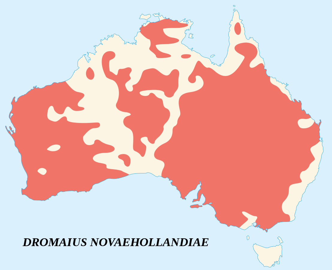
English: Emu's recorded observations map (Dromaius Novaehollandiae).
Areas where emu has been recorded. Français : Carte d'observations de l'Émeu d'Australie (Dromaius Novaehollandiae).
Zones où des émeus ont été observés. |
||
| Dedhyans | |||
| Pennfenten |
English:
Français : |
||
| Awtour | Sémhur (talk) | ||
| Askrifans (required by the license) | © Sémhur / Wikimedia Commons / | ||
| SVG | W3C-validity not checked.
|
||
| Atelier graphique |

| Camera location | | View this and other nearby images on: OpenStreetMap |
|---|
Leshyans
I, the copyright holder of this work, hereby publish it under the following licenses:
| Copyleft: This work of art is free; you can redistribute it and/or modify it according to terms of the Free Art License. You will find a specimen of this license on the Copyleft Attitude site as well as on other sites. |
This file is licensed under the Creative Commons Attribution-Share Alike 4.0 International, 3.0 Unported, 2.5 Generic, 2.0 Generic and 1.0 Generic license.
- Yma'n gwir dhywgh:
- a ranna – a dhasskrifa, lesranna ha treuskorra an ober
- a gemyska – a aswiwa an ober
- Yn-dann an ragselyow a syw:
- askrifans – Res yw dhywgh ri askrifans gwiw, provia kevren dhe'n lecyans, ha meneges mar peu chanjyow gwrys. Hwi a yll gul hemma yn fordh resonus a vynnowgh, mes ny yllir y wul yn fordh a broffo synser an lecyans dh'agas skoodhya po agas devnydh.
- ranna kehaval – Mar kwrewgh hwi chanjya, treusfurvya po drehevel war an ober ma, res yw dhywgh lesranna agas kevrohow yn-dann an keth lecyans hag an derowel, po lecyans kesplegadow.
You may select the license of your choice.
Istori an restren
Klyckyewgh war dhedhyans/eur rag gweles an folen dell o an termyn na.
| Dedhyans/Eur | Skeusennik | Mynsow | Devnydhyer | Kampol | |
|---|---|---|---|---|---|
| a-lemmyn | 15:09, 25 Metheven 2007 | | 1,108 × 903 (114 KB) | Sémhur | better coast lines |
| 11:29, 24 Metheven 2007 |  | 1,108 × 903 (72 KB) | Sémhur | {{Information |Description= {{fr|Carte d'observations de l'émeu (''Dromaius Novaehollandiae'').<br/>Légende : en marron, zones où des émeus ont été observés.}} {{en|Emu's recorded observations map (''Dromaius Novaehollandiae'').<br/>Legend : maroon |
Devnydh an restren
Yma an 2 folen a syw owth usya an restren ma:
Devnydh ollvysel an restren
Yma an wikis erel a syw ow tevnydhya an restren ma:
- Devnydh war an.wikipedia.org
- Devnydh war ar.wikipedia.org
- Devnydh war arz.wikipedia.org
- Devnydh war ast.wikipedia.org
- Devnydh war be.wikipedia.org
- Devnydh war bg.wikipedia.org
- Devnydh war bn.wikipedia.org
- Devnydh war ca.wikipedia.org
- Devnydh war ceb.wikipedia.org
- Devnydh war cs.wikipedia.org
- Devnydh war cy.wikipedia.org
- Devnydh war de.wikipedia.org
- Devnydh war en.wikipedia.org
- Devnydh war eo.wikipedia.org
- Devnydh war et.wikipedia.org
- Devnydh war eu.wikipedia.org
- Devnydh war fa.wikipedia.org
- Devnydh war fi.wikipedia.org
- Devnydh war ga.wikipedia.org
- Devnydh war gl.wikipedia.org
- Devnydh war gu.wikipedia.org
- Devnydh war he.wikipedia.org
- Devnydh war hr.wikipedia.org
- Devnydh war hu.wikipedia.org
- Devnydh war hy.wikipedia.org
- Devnydh war id.wikipedia.org
- Devnydh war incubator.wikimedia.org
- Devnydh war is.wikipedia.org
- Devnydh war ja.wikipedia.org
- Devnydh war jv.wikipedia.org
- Devnydh war ka.wikipedia.org
- Devnydh war kk.wikipedia.org
- Devnydh war kn.wikipedia.org
- Devnydh war ko.wikipedia.org
- Devnydh war la.wikipedia.org
- Devnydh war lt.wikipedia.org
- Devnydh war lv.wikipedia.org
- Devnydh war mk.wikipedia.org
- Devnydh war ml.wikipedia.org
- Devnydh war ms.wikipedia.org
- Devnydh war my.wikipedia.org
- Devnydh war nn.wikipedia.org
- Devnydh war no.wikipedia.org
- Devnydh war nv.wikipedia.org
- Devnydh war or.wikipedia.org
- Devnydh war pa.wikipedia.org
- Devnydh war pl.wikipedia.org
Gweles devnydh ollvysel moy a'n restren ma.