Restren:Thessaly.jpg
Myns an ragwel ma: 665 × 600 piksel. Klerderyow erel: 266 × 240 piksel | 532 × 480 piksel | 894 × 806 piksel.
Restren wreydhek (894 × 806 piksel, myns an restren: 1.18 MB, eghen MIME: image/jpeg)
| Restren dhyworth Wikimedia Commons yw hebma. Yma diskwedhys a-woles derivadow dhyworth y folen deskrifans ena. | Mos dhe folen an restren war Wikimedia Commons |
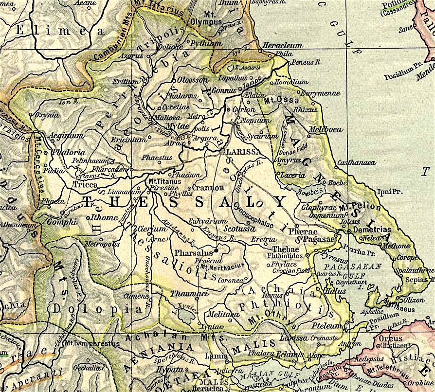
Map of Thessaly, cropped from old public domain map of Greece, from the Perry-Castañeda Library Map Collection, Historical Atlas by William R. Shepherd north, south
This file is licensed under the Creative Commons Attribution 3.0 Unported license.
- Yma'n gwir dhywgh:
- a ranna – a dhasskrifa, lesranna ha treuskorra an ober
- a gemyska – a aswiwa an ober
- Yn-dann an ragselyow a syw:
- askrifans – Res yw dhywgh ri askrifans gwiw, provia kevren dhe'n lecyans, ha meneges mar peu chanjyow gwrys. Hwi a yll gul hemma yn fordh resonus a vynnowgh, mes ny yllir y wul yn fordh a broffo synser an lecyans dh'agas skoodhya po agas devnydh.
Istori an restren
Klyckyewgh war dhedhyans/eur rag gweles an folen dell o an termyn na.
| Dedhyans/Eur | Skeusennik | Mynsow | Devnydhyer | Kampol | |
|---|---|---|---|---|---|
| a-lemmyn | 12:40, 1 Du 2021 | | 894 × 806 (1.18 MB) | Claude Zygiel | Lighter |
| 15:44, 2 Hedra 2010 |  | 894 × 806 (680 KB) | Cplakidas | widened to include Magnesia, which was considered part of wider Thessaly | |
| 08:22, 12 Kevardhu 2006 |  | 769 × 778 (226 KB) | Roke~commonswiki | Map of Thessaly, cropped from old public domain map of Greece, from the Perry-Castañeda Library Map Collection, Historical Atlas by William R. Shepherd [http://www.lib.utexas.edu/maps/historical/shepherd/greece_ancient_n_ref_1926.jpg north], [http://www. |
Devnydh an restren
Yma an folen a syw owth usya an restren ma:
Devnydh ollvysel an restren
Yma an wikis erel a syw ow tevnydhya an restren ma:
- Devnydh war an.wikipedia.org
- Devnydh war bg.wikipedia.org
- Devnydh war ca.wikipedia.org
- Devnydh war ceb.wikipedia.org
- Devnydh war cs.wikipedia.org
- Devnydh war de.wikipedia.org
- Devnydh war el.wikipedia.org
- Devnydh war en.wikipedia.org
- Thessaly
- Pagasae
- Demetrias
- Phylace (Thessaly)
- Pherae
- Tripolis Larisaia
- Tripolis (Perrhaebia)
- Pythion
- Doliche (Thessaly)
- History of Thessaly
- Palaepharsalus
- Argissa Magoula
- Eurymenae
- Amphrysus
- Gomphi
- Halos (Thessaly)
- Homolium
- Rhizus
- Tricca
- Phalanna
- Perrhaebia
- Pelasgiotis
- Ancient Thessaly
- Pimpleia
- Pelinna
- Pharcadon
- Argos Pelasgikon
- Boebe (Thessaly)
Gweles devnydh ollvysel moy a'n restren ma.